http://www.latimes.com/news/local/la-me-0719-compton-bankruptcy-20120719,0,7289469.story?page=1.
Tuesday, July 24, 2012


Tuesday, July 17, 2012
Wildfire, Kern County
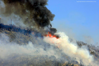
A wildfire near Tehachapi CA is burning out of control at this hour, over 1,500 acres have been consumed, no buildings lost, one bridge was destroyed by fire. No estimate on containment yet. The fire was burning in grass and mixed brush and moving into heavier fuel. The fire is north of Highway 58 and east of Pine Canyon RD near the Monolith Cement plant in Sand Canyon. BLM, Cal Fire, Forest Service and Kern County are working the blaze.




 Thunderstorms and more monsoonal flow tomorrow, chance of lightning in Zone 288 and the LA basin from tropical storm Fabio 500 miles to the south. Warmer drier air mass later in the week, then a chance of more lightning after the weekend.


Monday, July 9, 2012
Critical Fire Weather Alert
For Zone 288 temperatures hit 106 degrees today with a fairly strong onshore winds. Low relative humidity's with poor night time recovery are observed.
Several fires near zone 288 yesterday, one in Kern County near the town of Lebec, approximately 100 acres at Lebec Oak Rd and Lancer Rd just west of Interstate 5, had some minor structure protection issues associated with this fire. Kern County and United States Forest Service handled the brunt of the attack.
Today Cal Fire has a 3,000 acre grass fire near Parkfield to the north. No structure loss reported as of yet. Cal Fire and San Bernardino also had a brush start near Highway 18, about 50 acres reported near Old Waterman Canyon.
There is potential for dry lightning Wednesday and Thursday if monsoonal moisture moves in from the south east. Dry lightning could be a cause for alarm since fuels are tinder dry and temperatures will be near triple digit readings.


Several fires near zone 288 yesterday, one in Kern County near the town of Lebec, approximately 100 acres at Lebec Oak Rd and Lancer Rd just west of Interstate 5, had some minor structure protection issues associated with this fire. Kern County and United States Forest Service handled the brunt of the attack.
Today Cal Fire has a 3,000 acre grass fire near Parkfield to the north. No structure loss reported as of yet. Cal Fire and San Bernardino also had a brush start near Highway 18, about 50 acres reported near Old Waterman Canyon.
There is potential for dry lightning Wednesday and Thursday if monsoonal moisture moves in from the south east. Dry lightning could be a cause for alarm since fuels are tinder dry and temperatures will be near triple digit readings.


Saturday, July 7, 2012
Critical Fire Weather Zone 288
Warming and drying trend, periods of very low RH and hot temperatures producing long periods of critical fire weather for zone 288. Potential for dry lightning Monday-Wednesday with south east flow.
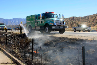 Initial attack was light today, one small spot fire along Interstate 5 near Highway 138 and Copco RD, less than a quarter acre. United States Forest Service and Los Angles County Fire Departmant had quick knock down.

Thursday, July 5, 2012
Fire Weather Zone 288
...WARMING AND DRYING TREND ACROSS INTERIOR SECTIONS FRIDAY THROUGH SUNDAY...WITH PERIODS OF SINGLE DIGIT HUMIDITIES ACROSS THE MOUNTAINS AND ANTELOPE VALLEY...
...SLIGHT CHANCE OF THUNDERSTORMS FOR THE MOUNTAINS AND ANTELOPE VALLEY MONDAY THROUGH THURSDAY...Heightened fire weather concerns for triple digit temperatures, low RH and potential for lightning next week.
Fourth of July so no large scale fires in fire weather zone 288. A cumulus cell did develope near Edward Air Force Base, no fires reported from lightning activity.
...SLIGHT CHANCE OF THUNDERSTORMS FOR THE MOUNTAINS AND ANTELOPE VALLEY MONDAY THROUGH THURSDAY...Heightened fire weather concerns for triple digit temperatures, low RH and potential for lightning next week.
Fourth of July so no large scale fires in fire weather zone 288. A cumulus cell did develope near Edward Air Force Base, no fires reported from lightning activity.
Wednesday, July 4, 2012
Slight Chance of Dry Lightning Eastern Deserts, Happy July 4th


Los Angeles County Fire Department assisted by the United States Forest Service had a third alarm wildfire on the west side of Palmdale in the Old Crown Valley burn area last night, south of Elizabeth Lake Road. Approximately 200 acres consumed, primarily in grass and light sage, 4-10 foot flame lengths noted, wind was gusting at 25 MPH. The fire was under control by 02:00 am.
Fireworks are a concern for tonight and residual ignitions for tomorrow. Happy 4th of July everyone, stay safe.
Sunday, July 1, 2012
Oasis IC, Wildfire in Pinon Hills
Los Angeles County, San Bernardino, Cal Fire and United States Forest Service contained a 96 acre brush fire in Pinon Hills at 263 East and Highway 138. Homes along Smoke Tree Rd and Pine View were provided structure protection. The fire was contained after several hours of good dozer and aircraft support.
Fire Weather in Zone 288:Temperatures a few degrees cooler in the Antelope Valley today, strong gusty canyon winds from onshore push still a concern. More moisture in the air mass is noted today with some clouds visible above the Tehachapi Range.


Fire Weather in Zone 288:Temperatures a few degrees cooler in the Antelope Valley today, strong gusty canyon winds from onshore push still a concern. More moisture in the air mass is noted today with some clouds visible above the Tehachapi Range.


Subscribe to:
Posts (Atom)

 Posts


